Find Your Right West Metro Community
Compare West Metro Atlanta cities, market snapshots, ZIP code differences, available homes, location, new construction, schools, commute routes, monthly payment and lifestyle before you tour.

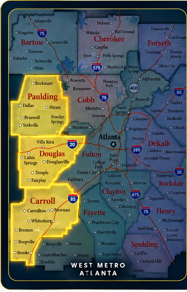
Explore West Metro Cities
Select a city to jump directly to its market, map, ZIP code comparison, and home-search section.
Douglas County Cities
I-20 West communities with established neighborhoods, newer housing, recreation and convenient Atlanta access.
Paulding County Cities
Growing west-side communities with newer neighborhoods, additional space and convenient access toward Cobb and Douglas.
Carroll County Cities
West Georgia communities ranging from the Carrollton hub to I-20 towns, smaller communities and more rural settings.
Current City Market Snapshot Highlights
Start with the overall city numbers, then open each city guide to see where the city is located and compare the market by ZIP code before you search for homes.
Douglas County
Douglasville
Lithia Springs
Austell
Winston
Paulding County
Dallas
Hiram
Carroll County
Carrollton
Villa Rica
Temple
Bremen
Whitesburg
The detailed sections below show each city's West Metro relationship and break the market down by ZIP code so buyers can compare pricing, inventory, location and search areas before touring homes.
Douglasville Market & ZIP Code Guide
Compare Douglasville’s current city market snapshot, see how the city relates to nearby West Metro communities, and compare the two primary Douglasville home-search areas: 30134 and 30135.
Where Is Douglasville?
Douglasville is highlighted so you can compare its location with nearby West Metro communities and major transportation corridors. Click any city to open a detailed interactive map that can be moved and zoomed.
Douglasville
Use the citywide market numbers in this card as your starting point, then compare the 30134 and 30135 search areas below.
- ✓Direct I-20 access toward Atlanta and the broader West Metro corridor.
- ✓Established neighborhoods, newer construction, townhomes and larger-lot properties can all be part of the search.
- ✓Downtown Douglasville, Arbor Place, parks and nearby Sweetwater Creek State Park add local destinations and recreation.
- ✓Click any city on the relationship map to compare its location with Douglasville without leaving the page.
Douglasville by ZIP Code
Homes in 30134
Compare current 30134 homes by price, property type, neighborhood setting, condition and access to your regular destinations.
Homes in 30135
Compare current 30135 homes, including established subdivisions, newer communities, larger homes and properties farther south of I-20.
About the numbers: Douglasville citywide statistics refresh from the current Lofty city market page when the source can be read. ZIP inventory refreshes from the matching property search. A ZIP median price is shown only when a genuine ZIP-specific median can be identified. ZIP codes are search and mailing areas and do not independently determine city limits, schools, taxes or municipal services.
Compare the Remaining West Metro Cities
Each section follows the same market, location and ZIP-search format so buyers can compare communities without changing how the page works from city to city.
Lithia Springs Market & ZIP Code Guide
Compare the citywide market snapshot, local orientation and current ZIP-code home searches before deciding where to focus.
Where Is Lithia Springs?
Lithia Springs is highlighted so you can compare its location with nearby West Metro communities and major transportation corridors. Click a city on the map to open its interactive map.
Schematic relationship map for general orientation. Transportation corridors and city locations are simplified and the map is not to scale.
Open Interactive Lithia Springs Map ↗Lithia Springs Overview
- I-20 access toward Douglasville, Cobb County and Atlanta.
- Sweetwater Creek State Park is a major nearby recreation destination.
- Established neighborhoods and newer housing options are available throughout the 30122 search area.
Current Market Snapshot
Snapshot updates from the current Lofty city market page.
Lithia Springs by ZIP Code
1 ZIP searchI-20 / Sweetwater Creek area search covering established neighborhoods, newer homes and convenient west-side access.
ZIP inventory refreshes from the matching property search when the source can be read. ZIP median price displays only when a genuine ZIP-specific median is found. Verify jurisdiction, schools, taxes and municipal services for the specific property address.
Austell Market & ZIP Code Guide
Compare the citywide market snapshot, local orientation and current ZIP-code home searches before deciding where to focus.
Where Is Austell?
Austell is highlighted so you can compare its location with nearby West Metro communities and major transportation corridors. Click a city on the map to open its interactive map.
Schematic relationship map for general orientation. Transportation corridors and city locations are simplified and the map is not to scale.
Open Interactive Austell Map ↗Austell Overview
- Austell extends into both Cobb and Douglas counties, so property-specific county jurisdiction should be verified by address.
- Home searches include established subdivisions, townhomes and single-family options.
- I-20 and nearby I-285 connections support access toward Atlanta and surrounding job centers.
Current Market Snapshot
Snapshot updates from the current Lofty city market page.
Austell by ZIP Code
2 ZIP searchesCompare established neighborhoods, townhomes and single-family homes around central Austell.
Compare southern and southeastern Austell-area searches with convenient access toward I-20 and I-285.
ZIP inventory refreshes from the matching property search when the source can be read. ZIP median price displays only when a genuine ZIP-specific median is found. Verify jurisdiction, schools, taxes and municipal services for the specific property address.
Winston Market & ZIP Code Guide
Compare the citywide market snapshot, local orientation and current ZIP-code home searches before deciding where to focus.
Where Is Winston?
Winston is highlighted so you can compare its location with nearby West Metro communities and major transportation corridors. Click a city on the map to open its interactive map.
Schematic relationship map for general orientation. Transportation corridors and city locations are simplified and the map is not to scale.
Open Interactive Winston Map ↗Winston Overview
- Winston offers a lower-density search option west of central Douglasville.
- Buyers often compare larger lots, established homes and newer construction.
- Location works well for buyers who want Douglas County access with a more rural setting.
Current Market Snapshot
Snapshot source: current Winston Lofty city market page. Live loader refreshes these values when the source can be read.
Winston by ZIP Code
1 ZIP searchCompare Winston-area homes, larger lots and more rural residential settings west of Douglasville.
ZIP inventory refreshes from the matching property search when the source can be read. ZIP median price displays only when a genuine ZIP-specific median is found. Verify jurisdiction, schools, taxes and municipal services for the specific property address.
Dallas Market & ZIP Code Guide
Compare the citywide market snapshot, local orientation and current ZIP-code home searches before deciding where to focus.
Where Is Dallas?
Dallas is highlighted so you can compare its location with nearby West Metro communities and major transportation corridors. Click a city on the map to open its interactive map.
Schematic relationship map for general orientation. Transportation corridors and city locations are simplified and the map is not to scale.
Open Interactive Dallas Map ↗Dallas Overview
- Dallas is a major Paulding County residential center with established and newer communities.
- Buyers can compare suburban neighborhoods, larger-lot properties and new construction.
- Road connections lead toward Hiram, Acworth, Cobb County and Douglas County.
Current Market Snapshot
Snapshot updates from the current Lofty city market page.
Dallas by ZIP Code
2 ZIP searchesCompare downtown, north Paulding and newer-community searches around Dallas.
Compare southern Dallas-area neighborhoods with access toward Hiram and Douglas County.
ZIP inventory refreshes from the matching property search when the source can be read. ZIP median price displays only when a genuine ZIP-specific median is found. Verify jurisdiction, schools, taxes and municipal services for the specific property address.
Hiram Market & ZIP Code Guide
Compare the citywide market snapshot, local orientation and current ZIP-code home searches before deciding where to focus.
Where Is Hiram?
Hiram is highlighted so you can compare its location with nearby West Metro communities and major transportation corridors. Click a city on the map to open its interactive map.
Schematic relationship map for general orientation. Transportation corridors and city locations are simplified and the map is not to scale.
Open Interactive Hiram Map ↗Hiram Overview
- Hiram is a convenient Paulding County shopping and residential hub.
- The 30141 search includes established neighborhoods, townhomes and newer subdivisions.
- Location provides connections toward Dallas, Powder Springs and Douglasville-area routes.
Current Market Snapshot
Snapshot updates from the current Lofty city market page.
Hiram by ZIP Code
1 ZIP searchCompare Hiram neighborhoods near shopping, schools, parks and the Dallas Highway corridor.
ZIP inventory refreshes from the matching property search when the source can be read. ZIP median price displays only when a genuine ZIP-specific median is found. Verify jurisdiction, schools, taxes and municipal services for the specific property address.
Carrollton Market & ZIP Code Guide
Compare the citywide market snapshot, local orientation and current ZIP-code home searches before deciding where to focus.
Where Is Carrollton?
Carrollton is highlighted so you can compare its location with nearby West Metro communities and major transportation corridors. Click a city on the map to open its interactive map.
Schematic relationship map for general orientation. Transportation corridors and city locations are simplified and the map is not to scale.
Open Interactive Carrollton Map ↗Carrollton Overview
- Carrollton is a regional West Georgia hub for shopping, medical services and education.
- Home searches range from established neighborhoods to newer communities and larger properties.
- Buyers can compare central-city convenience with quieter areas on the edges of the market.
Current Market Snapshot
Snapshot updates from the current Lofty city market page.
Carrollton by ZIP Code
2 ZIP searchesCompare eastern and southern Carrollton-area homes, subdivisions and access toward Villa Rica.
Explore central Carrollton, established neighborhoods and western search areas.
ZIP inventory refreshes from the matching property search when the source can be read. ZIP median price displays only when a genuine ZIP-specific median is found. Verify jurisdiction, schools, taxes and municipal services for the specific property address.
Villa Rica Market & ZIP Code Guide
Compare the citywide market snapshot, local orientation and current ZIP-code home searches before deciding where to focus.
Where Is Villa Rica?
Villa Rica is highlighted so you can compare its location with nearby West Metro communities and major transportation corridors. Click a city on the map to open its interactive map.
Schematic relationship map for general orientation. Transportation corridors and city locations are simplified and the map is not to scale.
Open Interactive Villa Rica Map ↗Villa Rica Overview
- Villa Rica extends into both Carroll and Douglas counties along the I-20 corridor.
- Buyers can compare established neighborhoods, newer communities and more space farther west.
- The location provides a direct interstate route toward Douglasville and Atlanta.
Current Market Snapshot
Snapshot updates from the current Lofty city market page.
Villa Rica by ZIP Code
1 ZIP searchCompare Villa Rica homes, lake-community options, newer construction and I-20 access.
ZIP inventory refreshes from the matching property search when the source can be read. ZIP median price displays only when a genuine ZIP-specific median is found. Verify jurisdiction, schools, taxes and municipal services for the specific property address.
Temple Market & ZIP Code Guide
Compare the citywide market snapshot, local orientation and current ZIP-code home searches before deciding where to focus.
Where Is Temple?
Temple is highlighted so you can compare its location with nearby West Metro communities and major transportation corridors. Click a city on the map to open its interactive map.
Schematic relationship map for general orientation. Transportation corridors and city locations are simplified and the map is not to scale.
Open Interactive Temple Map ↗Temple Overview
- Temple is primarily in Carroll County with a smaller portion extending into Haralson County along the western I-20 corridor.
- Searches include traditional subdivisions, newer homes and more rural residential options.
- Buyers can compare Temple with Villa Rica, Carrollton and Bremen depending on commute and space needs.
Current Market Snapshot
Snapshot updates from the current Lofty city market page.
Temple by ZIP Code
1 ZIP searchCompare Temple homes, newer subdivisions and rural residential properties near the I-20 corridor.
ZIP inventory refreshes from the matching property search when the source can be read. ZIP median price displays only when a genuine ZIP-specific median is found. Verify jurisdiction, schools, taxes and municipal services for the specific property address.
Bremen Market & ZIP Code Guide
Compare the citywide market snapshot, local orientation and current ZIP-code home searches before deciding where to focus.
Where Is Bremen?
Bremen is highlighted so you can compare its location with nearby West Metro communities and major transportation corridors. Click a city on the map to open its interactive map.
Schematic relationship map for general orientation. Transportation corridors and city locations are simplified and the map is not to scale.
Open Interactive Bremen Map ↗Bremen Overview
- Bremen extends into both Haralson and Carroll counties, with most of the city associated with Haralson County.
- The 30110 search includes established neighborhoods, newer homes and more rural properties.
- I-20 provides a direct east-west connection toward Carrollton, Villa Rica and Metro Atlanta.
Current Market Snapshot
Snapshot updates from the current Lofty city market page.
Bremen by ZIP Code
1 ZIP searchCompare Bremen homes, established neighborhoods and West Georgia properties near I-20.
ZIP inventory refreshes from the matching property search when the source can be read. ZIP median price displays only when a genuine ZIP-specific median is found. Verify jurisdiction, schools, taxes and municipal services for the specific property address.
Whitesburg Market & ZIP Code Guide
Compare the citywide market snapshot, local orientation and current ZIP-code home searches before deciding where to focus.
Where Is Whitesburg?
Whitesburg is highlighted so you can compare its location with nearby West Metro communities and major transportation corridors. Click a city on the map to open its interactive map.
Schematic relationship map for general orientation. Transportation corridors and city locations are simplified and the map is not to scale.
Open Interactive Whitesburg Map ↗Whitesburg Overview
- Whitesburg offers a smaller-town and rural residential search environment.
- Buyers often compare larger lots, established homes and properties outside denser suburban areas.
- The location remains connected to Carrollton, Douglasville and other West Metro communities.
Current Market Snapshot
Snapshot updates from the current Lofty city market page.
Whitesburg by ZIP Code
1 ZIP searchCompare Whitesburg-area homes and larger-lot properties in a quieter Carroll County setting.
ZIP inventory refreshes from the matching property search when the source can be read. ZIP median price displays only when a genuine ZIP-specific median is found. Verify jurisdiction, schools, taxes and municipal services for the specific property address.
Compare the Location, the Home and the Numbers
The right West Metro city is not just about the list price. Compare the exact location, monthly payment, property condition and long-term fit before you decide where to focus.
Compare Location
Use the city and ZIP guides above to compare commute routes, nearby communities, schools and the exact jurisdiction for each property.
Compare Payment
Price is only part of the decision. Look at loan type, down payment, taxes, insurance, HOA costs and estimated cash needed to close.
Compare the Home
Evaluate condition, age, lot size, layout, new construction versus resale and how the property fits your day-to-day plans.
Ready to know what your home search can look like?
Start with financing, then use the market and ZIP comparisons above to focus on homes that fit both your lifestyle and your numbers.
Financing information is for planning purposes only. Loan eligibility, rates, payments and cash-to-close depend on the lender, borrower qualifications, property details and final loan terms.